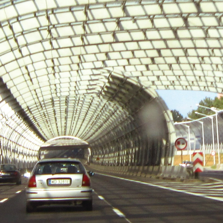
Highway in Warsaw, Poland (Petras Gagilas, CC BY-SA)
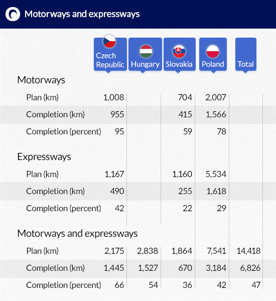
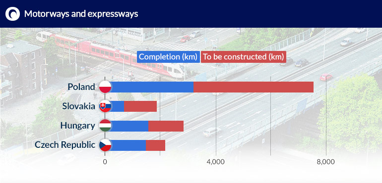
The planned network of highways and expressways in Poland, the Czech Republic, Hungary and Slovakia is to have a total length of over 14,400 kilometres. More than half of these roads will be located Poland. The progress of highway construction works in the individual countries of CEE region is varied. As a rule, however, in each country, greater emphasis is put on the construction of highways, and so their construction is far more advanced than expressways.
Czech Republic in the lead
The Czech Republic is the regional leader in terms of highway construction. Its government adopted a plan for the construction of a network of highways and expressways in July 1999. It was updated more than 740 times in the following years. The current plan provides for the construction of a network of six highways with a total length of 1,008 km, marked with the letter D (from the Czech word dálnice), i.e. D1, D2, D3, D5, D8 and D11.
A large part of the Czech highways forms fragments of the pan-European transport corridors covered by the TINA program (Transport Infrastructure Needs Assessment) of the European Union. Three such corridors run through the territory of the Czech Republic: IV (Dresden-Prague-Bratislava-Budapest-Istanbul) and its version A, i.e. the branch connecting Nuremberg and Prague, as well as version B of corridor VI on the Katowice-Ostrava-Brno section. Four Czech highways overlap with these corridors. This includes: the entire D1 from Prague, through Brno and Ostrava up to the Polish border (with a total length of 376 km), the entire D2 from Brno to the border with Slovakia (total length of 61 km), the entire D5 from Prague through Pilsen to the border with Germany (total length of 151 km) and the entire D8 from Prague through Usti and Labem to the border with Germany (length of 92 km), as well as a part of Prague’s ring road (which does not have a highway status). The highway sections of these routes have a total length of 640 kilometres and are 94.7 per cent completed (as of April 2015). The missing 12-kilometre long section of the D8 is currently under construction and the 24-kilometre long section of the D1 is undergoing preparatory works.
(infographics: Darek Gąszczyk)
In addition, according to government plans, two other highways will be operating in the Czech Republic: the D3 from Prague going south through Ceske Budejovice to the border with Austria (a total length of 172 km) and from Prague to the north-east via Hradec Králové to the Polish border (planned length of 154 km). They are 40 per cent completed (as at April 2015), which is significantly less than the above mentioned highways overlapping with the pan-European transport corridors.
In addition, the Czech Republic has planned a network of expressways, which are marked with the letter R (from the Czech word rychlostní silnice). Their planned total length is 1,167 km. However, thus far (as of April 2015) the projects have been completed to less than 42 per cent (i.e. about 490 km).
Out of the planned 14 expressways, only three roads are fully completed: the R10 from Prague through the town of Mladá Boleslav to Turnov, the R46 from Vyškov to Olomouc and the R63 connecting Bystrovany with Řehlovice. They have a total length of 118 km. So far not a single kilometre has been opened for traffic on other two planned expressways – the R43 from Brno to Moravská Třebová and the R49 from Hulin to the border with Slovakia. Their planned total length is 137 km.
In total, the government plans for the construction of highways and expressways, with a total length of 2,170 kilometres, have been completed in almost 58 per cent (approx. 1,260 km).
Hungary lacking part of the plans
The progress in the construction of highways is similar in Hungary. It should be noted, however, that in Hungary there is no clear distinction between highways and expressways. Both are marked with the letter M (as in: Magyar autópályák, Hungarian highway). The standards of highways, however, are primarily limited to the radial roads leading from the capital towards the borders. This includes the M1 –leading from Budapest westward to the border with Austria, the M3 – running eastward to the border with Ukraine, the M5 – running to the southeast towards the border with Serbia, and two roads linking the Hungarian capital with Croatia, i.e. the M6, which runs southward and the M7, which runs to the southwest. The combined length of these highways is currently (as of April 2015) just over 1,030 km, which represents almost 96 per cent of the planned length. The missing parts are the almost 30-kilometre long section of the M3 and approximately 20 kilometres of the M6 highway.
In addition to these roads, small sections of M8, M30, M31, M35, M43 and M60 also are classified as a highway. The remaining Hungarian highways are the equivalent of Polish expressways. Apart from a few exceptions, the level of advancement in the implementation of these projects is quite low. The construction of many roads has not even started yet. The implementation of the plans for the construction of highways other than the five key highways (M1, M3, M5, M6 and M7) has currently reached about 28 per cent.
In addition, in Hungary the plans for the construction of highways and expressways are still not complete (for example, the future length and route of the M11 and the M44 are not determined). So far the Hungarian authorities have determined the route of 26 highways and expressways (from M0, which is the Budapest ring road, to the M87 from the city of Szombathely to the border with Austria). The combined length of all these highways is approx. 2 840 kilometres. So far 1 530 kilometres have been completed (i.e. almost 54 percent).
Delays in Slovakia
The construction of the planned network of highways and expressways in Slovakia is far less advanced than in the Czech Republic and Hungary. There are also three Pan-European transport corridors running through its territory: IV, which is to connect the territory of the Czech Republic and Hungary through Bratislava, V in version A from Bratislava through Žilina to Uzhhorod in Ukraine and further to Lviv, and VI from Poland to Žilina. These routes overlap with three highways marked as D1, D2 and D3 (from the word dialnica). The construction of highway D4 is also planned in Slovakia. It is to start near the border with Austria, encircle Bratislava and return to Austria, de facto functioning as a ring road of Slovakia’s capital city.
The combined length of all four highways planned in Slovakia is 704 kilometres. At the end of 2014, government plans were 59 per cent completed. The only fully completed road was the D2 (from the border with the Czech Republic through Bratislava to the border with Hungary) with a length of about 80 km. The completion of the D1 highway, which is the longest (nearly 516 km) and the most important transit highway in Slovakia, reached 62 per cent at the end of 2014. Four additional sections (in the area of Žilina and Martin, Ružomberok, Spišská Nová Ves and to the west towards Prešov) were being constructed. However, to the east of Košice, the future route of the D1 highway has only been marked out.
Only small stretches of the remaining two highways planned by the authorities – the D3 and D4 – are completed (between several and around a dozen percent of the scheduled length).
The work on the construction of the planned network of expressways (marked with the letter R from the Slovak name rýchlostné cesty) is much less advanced. Out of the planned 1,160 kilometres only a little over 22 per cent is completed. The most advanced of the nine expressways is the R1, which is to connect Trnava with Ružomberok (length of 225 km). Right now it reaches Banská Bystrica, which means that the construction plans have been implemented in 75 per cent. Four other expressways have short stretches completed (not exceeding 35 km): the R2, the R3, the R4 and the R6. The remaining four are at the most under construction and not a single kilometre of these roads has been opened to traffic yet.
The Slovak government is planning the construction of almost 1,870 kilometres of highways and expressways in the country. For the time being, these plans have been completed to approximately 36 per cent.
(infographics: Darek Gąszczyk)
Poland is halfway
The Polish government’ plans provide for the construction of three highways crossing the whole country – one from north to south and two from west to east. These are the A1 from Gdańsk to the village of Gorzyczki on the border with the Czech Republic, the A2 from Świecko on the border with Germany to the village of Kukuryki, where the road border crossing between Poland and Belarus is located, and the A4 connecting Jędrzychowice on the German border with Korczowa near the border with Ukraine. The construction of the last one is the most advanced: so far (as of April 2015) nearly 631 of the planned 672 kilometres have been completed. On the A2 highway 475 km of the planned 624 kilometres are open for traffic, and on the A1 – 406 of the planned 582 kilometres have been completed.
The government plans also provide for the construction of several shorter sections of highways with a length of several tens of kilometres: the A6 from Kołbaskowo on the border with Germany to Rzęśnica (24.3 kilometers completed of the planned 29 km), the fully completed A8 from Bielany Wrocławskie to Wrocław (22.3 km) and the A18 from Olszyna on the German border to Krzyżowa, where it would link with the A4 (the entire route is to stretch over 78.5 km, out of which only a 7-kilometre section is completed and only one northern carriageway, which is not marked as a highway, is operational over the remaining 71.5 kilometres). In total, the highway construction plans have so far been completed to 78 per cent.
The plans also envisage the construction of 5,534.1 kilometres of expressways. This network will consist of 19 roads (from S1 to S79). Currently, two of them are fully passable (the S22 from Elbląg to Grzechotki and the S79 between the Warsaw Airport and the Warsaw Marynarska junctions), while all the remaining roads are at various stages of construction (from the S74 Sulejów-Nisko with only several percent completed, to the S8 between Wrocław and Białystok, which is 75 per cent completed). In total, 1,617.6 kilometres of expressways have been put into operation, which represents 29.2 per cent of the planned network, whereas another 422 kilometres are currently under construction.
If we consider the combined length of highways and expressways in Poland, the plans for their construction have been completed in 42.2 per cent.
Catching up with the EU average
It should be noted that despite some important changes introduced in the initial plan for the construction of highways in Poland (the most notable example being the abandonment of the construction of highway A3 from Szczecin to Lubawka on the border with the Czech Republic, which was replaced with the expressway S3), the Polish authorities’ plans in this regard are quite ambitious. Even now, at the current stage of the works – we have 3,200 kilometres of highways and expressways – Poland’ network ranks 6th in the European Union in terms of length. The country overtook Portugal and the Netherlands a long time ago. According to the estimates of Adrian Furgalski from the Economic Advisors Team TOR, already in 2016 or by 2017 at the latest we will surpass the United Kingdom, which has a network of approximately 3,550 kilometres of highways. According to him, by the end of 2015 the density of highways in Poland could reach about 53 percent of the average density in the European Union.
Furgalski also reminds us that Poland began its road investments fairly late – even in comparison with other countries of the region. In this respect, we should be comparing ourselves with Croatia rather than the Czech Republic or Hungary. These countries embarked on building their highways and expressways as early as in the 1990s, not waiting for accession to the EU. Poland, on the other hand, started the first public highway investments only when EU funds became available, and they were not even included in the first budget perspective (completed in 2006). As a result, the construction of highways in the country only started gaining pace in the years 2007-2008. Before that the construction of highways in Poland was carried out by private business.
This was because the construction of the road network was not regarded as a priority by the Polish authorities. The Czechs and the Hungarians had a different approach. As a result their highways are completed in about 95 per cent and ours are less than 80 per cent finished.
And Poland made yet another mistake
“Both the Czechs and the Hungarians started with the construction of the most important sections of their highways and expressways, that is, those leading out of the capitals of their countries. After all, the greatest streams of traffic are found there”, says Adrian Furgalski. “It was entirely different in our case and Warsaw was probably the last capital in the EU to get a highway connection with the world.”
The Poles have been able to make up for these mistakes and the most important sections of the country’s highway system are already completed. The sections of the highways that still have to be completed are of secondary importance. These mainly include the central section of the A1 between Częstochowa and Tuszyn near Łódź, as well as the southern carriageway of the A18, and the section of the A2 leading from Mińsk to the border with Belarus.
“The traffic on this section of the A2 is likely to be low. For this reason, they even considered abandoning the earlier plans, but the government decided to build a highway there. But even if this section of the A2 wasn’t built, it wouldn’t be a big deal”, – says Furgalski.